
Teaching GeoDesign: A Campus-Wide Initiative by Ming-Chun Lee, Ph.D.
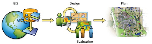
In recent years, GeoDesign has become a popular topic in the GIS community. Academics, practicing GIS communities, design and planning activists, and geospatial technology industries are all working together to create a definition to what GeoDesign encompasses and develop it into a practical design and planning framework. There are different opinions to what GeoDesign actually is, but in short GeoDesign combines GIS with designing the environment. In one way GeoDesign is an application that comes from geospatial analytics. In another it can allow us to “see through” earth’s landscape in order to understand the planet as a living system. Ultimately every party that collaborated on defining this term decided that it was just what it sounds like, something that combines GIS with design. GeoDesign allows people to design more closely to the environment, providing a “more synergistic coexistence”. Students involved in GeoDesign are taught to gain an awareness of the planet that will allow them to engage with the environment by learning relationships between the physical landscape and human systems. GeoDesign aims to “create and maintain more sustainable environments, communities and landscapes for the benefit of future generations”.
Lee, M. C., Ph.D. (n.d.). Teaching GeoDesign: A Campus-Wide Initiative. Sustainability on the UT Campus: A Symposium, 1-4. Retrieved January 25, 2016, from file:///Users/perikincaid/
This GeoDesign would be interesting to incorporate into the GIS class at SU.
ReplyDelete