Sunday, September 30, 2012

Is Urbanization heating things up?


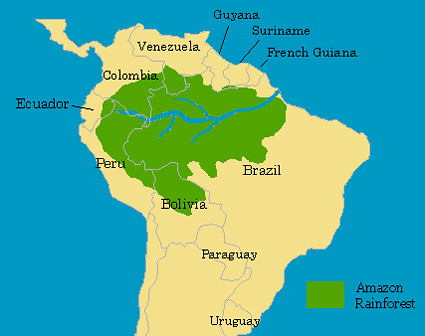
Q. Weng's study: "A remote sensing-GIS evaluation of urban expansion and its impact on surface temperature in the Zhujiang Delta, China" is fairly straightforward in its title, combining the use of remote sensing and GIS to determine how urban development has progressed and how it has changed surface temperatures in this delta region.
            Zhujiang Delta is the third largest river delta in China, this study focuses on the central area of the region in the “cities/counties: Guangzhou, Panyu, Sanshui, Nanhai, Foshan, Shunde, Jiangmen, Zhongshan, Zhuhai, Xinhui, Doumen, Zengcheng, Dongguan, Baoan and Shenxhen” (Weng, 2000). The Delta has an average temperature of 21-23 degrees Celsius, and has fertile sediment deposits as well as 1600 – 2600 mm of rain a year, making it one of the most agriculturally production regions of China. It also holds some of China’s biggest cities such as Hong Kong and Macao and has seen much development that has changed its land use and land cover. This study uses GIS to analyze such changes and their “impact on surface temperature” (Weng, 2000).
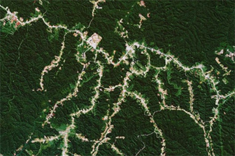
           
Urban expansion detection and analysis
            Land use/cover patterns were mapped for 1989 and 1997 using Landsat Thematic Mapper data. The land cover types identified are:
1.     urban or built-up land
2.     barren land
3.     cropland
4.     horticulture farms
5.     dike-pond land
6.     forest
7.     water

land use/cover changes were detected by collaborating quantitative areal data of gains and loses in each category between 1989 and 1997. Then, layers of city/county boundaries as well as major roads and major urban centers were overlaid and converted to raster format. 10 buffers of 500m each were put around one major road, the amount of urban expansion in each buffer zone was calculated to see the density of expansion in each buffer. These values were then used to see how distance from a road affects density of development.

Urbanization expansion impact analysis
            There is a distinct relationship between land texture and surface temperature, using this relationship, Weng was able to determine the impact of urban development on surface temperature in Zhujiang Delta. Weng converted the digital number of the thermal infrared data into radiant temperatures. Then, corrections were made to this temperature due to that fact that different land types radiate different amounts of radiation and light.  Land cover images and the temperatures of the land for each year between 1989 and 1997 were overlaid, allowing Weng to study the relationship between urbanized land use changes and temperatures.


Results
            During the 8-year study period, the area of urban/built-up land has increased by 47.68% and the area of horticulture farms has increased by 88.66%. Weng found that “most urban expansion (66%) can be observed within a distance of 2000m from a major road” (Weng, 2007), which helps decipher where development might happen in the future and where temperature increases are most likely to happen.

            Of the land cover types, urban/built-up land is resulted to have the highest surface radiant temperature. Barren land follows as having the second highest surface radiant temperature. The lowest temperatures were found in forests, followed by water bodies, dike-pond land and cropland.


Conclusion
            This study used remote sensing and GIS to evaluate rapid urban expansion and how it impacted surface temperatures in Zhujiang Delta. The study concluded that urban development increased between 1989 and 1997 in uneven parts of the delta, correlating with the placement of major roads. The study also found that urban development had a direct effect on the environment and raised temperatures by 13.01 K.
            The increase of surface temperature was found to be related to decrease in biomass, and development (and therefore temperature increase) in one area was shown to have a direct effect on other areas, such as forests that had not been developed.


Weng, Q. "A Remote Sensing-GIS Evaluation of Urban Expansion and Its Impact on Surface Temperature in the Zhujiang Delta, China." International Journal of Remote Sensing 22.10 (2001): 1999-2014. Print. 

The Fragmentation of Space in the Amazon Basin: Emergent Road Networks


Arima, Eugenio Y., Walker, Robert T., Sales, Marcio, Souza Jr., Carlos, and Perz, Stephen G. (2008). “The Fragmentation of Space in the Amazon Basin: Emergent Road Networks”. 699-709.

            
http://farm3.static.flickr.com/2459/3577304207_39342e49de.jpg
            
            Home to the world’s largest contiguous tropical forest, the Brazilian Amazon in its vastness has been losing coverage and its magnificent realm to loggers and those traveling the roads that traverse the natural forested expanse. Tropical deforestation has been an ongoing problem, negatively affecting biodiversity and the carbon cycle. Studying the emergence of deforestation and its patterns, specifically in relation to the consequences of the road networks that have branched off to further decimate the Amazon, the authors research the socio-spatial processes in effect.
            Through the replication of road networks, such as the dendritic (a common pattern of road fragmentation), GIS is used to map out the area and provide a greater understanding of the human forces that cause the habitat fragmentation and its continual proliferation. Decision-making in context with forested habitat and forested frontiers presents a number of challenges, one of which is key: resource exploitation and the subsequent degradation of non-human animal habitat.
            Roads built by loggers present a much greater problem to the environmental integrity of the Amazon rainforest than do those put in by the federal government. This is primarily due to the sheer number of them that bifurcate into various others, no matter the size of the roads themselves. Furthermore, they split off from the extensive road system already in place, further adding to the destruction, or often times, the eventual removal of species’ home- both arboreal and terrestrial. Additionally, the attraction of timber and the ease of access attracts more people, tracking in more potential for habitat degradation and loss from the influx of a one-sided, economically-eager human population.
            
            
             As mentioned earlier, the forest pattern studied here is classified as dendritic, a pattern that signifies a specific pattern other than patchy or independent settlement fragmentation, associated strictly with spatiality. Because of its spatial figure, GIS proves to be a key factor in the examination of the data, stressing the foremost form of forest loss due to massive logging practices and transportation of such.  
            Dijkstra’s algorithm via GIS tools generates networks and provides the most viable one, the best possible path after combining each path into a patchwork of data. Linkage of cells and a direction-to-origin-grid is implemented to eliminate the unnecessary routes collected. From Dijkstra’s algorithm sprang Tomlin’s heuristic hydrology approach. With this approach, Tomlin used the flow of water and its destination to estimate a similar path and thereby pinpoint the path of least resistance (and hence greater travel) to loggers and the like. Altogether, raster modeling was utilized to gather a substantial representation of non-equidistant tress across the Amazonian landscape. In addition, geostatistics and surveys helped to pinpoint the areas with the highest volume of timber (which, in turn, were also the areas that required the most roads to access the timber). The project conducted included forest inventories of over 2,000 Amazonian sites with measurement of trees over 23 centimeters, and the volume of trees per hectare was also accounted for. This project, based on kriging interpolation aided the researchers in defining the roads leading to logging sites- categorizing them as determinate and indeterminate roads. Below is a GIS map to this effect.
(Retrieved from original article)
            Defining the roads from raster modeling enabled the researchers to calculate the cost of the transverse of each cell and corresponding route/road. Slopes, rivers, and soil susceptible to flooding appear to be the most critical cost variables according to careful observation and surveys taken from loggers in the region. Other factors influencing cost, of which the majority of this article is focused, constitutes building/infrastructure costs as well as transportation costs. These costs demonstrate some of the ways loggers territorialize the landscape before logging is even considered.
            Overall the modeling suggests that loggers make rash judgments and insufficient spatial decisions while lacking sufficient information about the Amazonian landscape they manipulate. With the most forest clearance happening within the last decade (referenced in the article), loggers and all other players for that matter must acknowledge not only the personal costs they are managing, but also the residual environmental costs. Loggers’ imprint on the Amazon Rainforest currently is nothing more than an ominous reminder of the incessant human need for conquering, claiming, and convenience of nature. Rather than this dreadful impression, loggers and humans globally should leave behind stepping stones of the natural world, trademarks of the wonders of the rainforest for successive generations to marvel at in the same way we do today.  


For further reading, check out the article below:

GIS Helping Predict Future Forest Fires


https://lms.southwestern.edu/file.php/3722/Literature/Verbesselt-2002-EstimatingForestFires.pdf


Wildfire Risk Assessment in Virginia
 
Forest fires as a regular occurrence throughout the world. In previous history, fighting forest fires has been more reactive than proactive. With the use of new technology, specifically GIS, monitoring techniques can be used through satellite acquired data to look at certain characteristics that create an optimal situation for a forest fire. Looking at vegetation moisture, referenced with land cover, climatology, and other environmental aspects can result in the prediction of futuristic forest fires and help in the creation of fire prevention models.
            To fully understand the use of GIS as a way to predict future forest fires, one must first look deeper at the extensive characteristics that can affect the start of a forest first. Vegetation moisture is an obvious detail in prediction of forest fires, but there are numerous aspects of vegetation moisture that are acquired from the information. Explained in Estimation of fuel moisture context towards Fire Risk Assessment: A Review by J. Verbesselt, S. Fleck and P. Coppin (2002) , vegetation moisture helps show fire behavior factors such as “preheating and ignition of unburned fuels, rate of fire spread (or fire growth), rate of energy release, and production of smoke by burning and smoldering fuel” (p.1). Such statistical data as thermal remote sensing (which relates leaf water content to evapotranspiration rates) and thermal inertia method (which studies the daily rise and fall of temperatures in context of describing soil moisture) allow GIS to spatial show the information in a way that allows for prediction of forest fires. Futuristically, there is also the possibility that “manipulations of fuel type, load and arrangement could be used to help protect local areas of high value” (Verbesselt, Fleck & Coppin, 2002, p. 2). With these methods and numerous others Verbesselt, Fleck and Coppin (2002), in collaboration with GIS and coarse resolution imagery, prediction of forest fires forms “very sound approach is the integrated analysis of fire danger based on the combination of satellite data and meteorological danger indices” (p.8). The practical use of these models has been used by Flannigan, which results show that “the seasonal severity rating (SSR) will increase by 10-50% over most of North America” (Verbesselt, Fleck & Coppin, 2002, p.8). Finally, the ability of GIS and forest fire prediction models needs to be placed in a context that allows for a balance between the land owners and the environment, in hopes to people and resources from the destruction of fires while also not reduces the ecological niche of those fires.

            Forest fires can be extremely beneficial to the ecology of numerous environments, yet the ability to maintain these fires and reduce their impact on society is something that can have a great impact and needs to be researched further. With the technological advancements in recent history, GIS has taken a large role in gaining data on areas that has historical fire occurrence and those that may futuristically have fires. From this, the ability to predict and not react to forest fires has become more of a practical possibility.  


Works Cited

Verbesselt, J., Fleck, S., & Coppin, F. (2002). Estimation of fuel moisture content towards fire risk assessment: A review. Forest Fire Research and Wildland Safety Viegas (ed)

Saturday, September 29, 2012

Neogeography: Combining Geography and Art


Papadimitriou, Fivos. "A “Neogeographical Education”? The Geospatial Web, GIS and Digital Art in Adult Education." International Research In Geographical & Environmental Education 19, no. 1 (February 2010): 71-74. Academic Search Complete, EBSCOhost (accessed September 29, 2012).

Neogeography is a relatively new area within the realm of geography. According to Papadimitriou, neogeography is able to "engulf traditional geography as well as all forms of personal, intuitive...or artistic explorations and representations of geographical space, aided by new technologies associated with the Geospatial Web" (71). It can be highly subjective and can include data such as photography, text, music/sound, and video (see Figure 1).

Figure 1: Types of information and technologies that go into creating neogeographic works
Neogeography can be used to create a wide variety of maps and other works. Some types of works include photoblogging, microblogging, and radical cartographic mapping (see Figure 2). These kinds of works allow people to "gain new insights on geographical spaces which are supposedly already 'mapped' and 'known'" and add a personal and cultural dimension to mapping (72).

Figure 2: Type of neogeographical works resulting from the use of neogeography and associated technologies
Geo-tagging is an important component of neogeography, because it gives all non-geographical data a geographical reference. A good example I can think of to illustrate this concept is Facebook maps (see Figure 3). When adding photos, video, or text on Facebook, you can choose to include the location where it took place. Facebook takes it a step further and creates a map with a user-friendly interface allowing anyone to view all the geo-tagged data provided by any particular person. It allows you to see or read about all the places someone has been, organized by geographic location.

Figure 3: Facebook maps

Neogeography also has practical applications. Websites such as Wikimapia, Openstreetmap, and Google Maps allow anyone to add information and edit their maps. Users can do things such as add buildings or comment on businesses. Maps created by many people can have the advantage of being more detailed than conventional maps (see figure 4), but since they are not made by "professionals" they are also more likely to be inaccurate. 

Figure 4: Openstreetmap.org zoomed to Southwestern University campus
Papadimitriou believes that neogeography is an important step humanity has taken into the future. He states, "Never before has the global sharing of one's local experience been instantaneously possible" (74). Neogeography provides a new way for people to express themselves and interact with each other and the world.


Wednesday, September 19, 2012

Does your iPhone Really Know Where you are?


It may seem as though your phone can pinpoint your exact location, but the real answer is no, your “phone” does not know where you are. However your iPhone does use a combination of three different programs (A-GPS, WiFI Positioning, and Cellular Network Positioning) that all work together to roughly estimate your phones location at the time the GPS or Navigation application (Ap) is being used. 

When the first iPhone had been released there was only one complaint, no GPS feature. The technology for a device that used GPS was already in existence but the integration between phone and GPS had not yet been introduced. A year later the iPhone 3G was released which included a GPS application. 

After an article was released by Paul A Zandbergen on how the iPhone 3G uses A-GPS, WiFI Positioning, and Cellular Network Positioning to determine your location it was better understood that the phone itself does not know your location; it is the opening of the GPS Ap that configures the three programs to find your location. Once the configuration between the three had become available more applications began to integrate it for their own purposes. Some of these are “Restaurant Finder”, “Facebook”, “Weather Now”, etc.  

The three programs used for the configuration process overlap to get a more accurate reading on your location. A – GPS or Assisted GPS uses “many of the functions of a full GPS receiver, [but mostly] are performed by a remote GPS location server. This remote server provides the A-GPS mobile device with satellite orbit and clock information” (Zandberbergen, 2009). Just using A – GPS still provides a bit of inaccuracy compared to a GPS only device.
 “WiFi positioning uses terrestrial based WiFi access points (APs) to determine location” (Zandberbergen, 2009). These “terrestrial access points” are signals that your phone emits when using certain Ap’s. Because of the vast amount of people always on their phones using these applications it often causes an overlap in signals “creating a natural reference system for determining location.” 
Cellular positioning uses cells and towers to estimate your location. “When a user connects to the network, the mobile device is allocated to the base station transmitting with the strongest field strength. The most basic form of cellular positioning is to use the (known) location of this base station” (Zandberbergen, 2009). Because it only allocates your position to the closest tower or base your actual location is often off by a couple of miles.

So individually each program is slightly flawed which makes it undesirable to the user. In order to get a product that is accurate Apple merged the three programs together to give you the GPS system your phone currently uses to give the best accuracy. 
 Zandberbergen, P. A. (2009). Accuracy of iPhone Locations: A Comparison of Assisted GPS, WiFI, and Cellular Positioning. Transactions in GIS, 13, 5-25.