
Neighborhood Accessibility
GIS. Geographic Information Systems. or is it Geographic Information Science? Regardless as to whether GIS is a tool used for science or if it is itself a branch of science the process is constantly being innovated and increasing applications are being discovered. For instance, Jamie Pearce, Karen Witten, and Phil Bartie collaborated to create Neighbourhoods and health: a GIS approach to measuring community resource accessibility in J Epidemiol Community Health 2006;60:389–395. The trio basically took the concept of “food desserts” and applied it to all amenities a neighborhood would desire, as the authors themselves state: “this paper provides a novel methodology for calculating geographical accessibility to 16 types of health related community resources at a national level [New Zealand] across both urban and rural areas” (390).
New Zealand’s smallest unit of measurement is a meshblock which consist of around 100 people.
There are 38,350 total.
Methodology
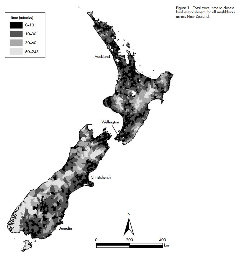
The study focused on “mortality, heart disease, and diabetes” and the “geographical accessibility to 16 types of health related community resources” in both urban and rural areas (390). Although the study was tailored to New Zealand's specific attributes the method was created with the plan to cross apply it to other countries. Contemporary national data was used to calculate the sub-domains which then could be used to create an aggregate. Road ways were used to measure distance instead of straight lines which entailed entering “speed limits, type of road surface, sinuosity and... the topography.” As an example below are two maps that represent a meshblock centroid to the closest food establishment and day care. This type of information could then be used to create an aggregate and the most convenient and least convenient quintiles highlighted.


Results
Beaches have a mean travel time of 23 minutes while parks have 3 and as expected “there is a strong urban-rural gradient” (393). The range of data was also pretty spread out as an urban center has less and a minute while a rural meshblock clocked in at 244 minutes mean travel time.
Moving Forward
This type of analysis is extremely important for urban planners or even just the city / state / country administration as a whole. If there are areas that are not accessible to the facilities that help in mitigating social ills, if not just mortality, heart disease, and diabetes, than those regions can not be expected to prosper. Moreover, the minority of people who do not possess the same transportation options as others would be in a severe disadvantage than their peers. All in all GIS is increasingly being used for important in not only mapping current locations but can used to create an aggregate of relative locations. Regardless if GIS is just a tool or a science it’s cool either way.
This is a very good way of using GIS especially in third world countries and countries like New Zealand where it is mostly untouched by man. This could be used to show the lack of food resources in third world countries, or show how far they must travel to get to a food market. I know my dad has said many people in Angola travel up to two hours on foot one way and two hours back, so using GIS you could present a plan to add closer markets.
ReplyDelete