
The more irregular the line, then the greater the increase between the 2 measurements at different scales. If irregular, D will be greater than 1.
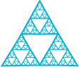
Self-similarity is defined as when any part of a feature is enlarged indistinguishable without vision of the feature as a whole. Irregular features are indistinguishable at all scales. This is used to create topographic scales.
In recursive subdivision of space, a self similar line is regenerated by recursive procedure. This was then used to develop algorithms to generate irregular fractal curves and surfaces. Self similarity is argued as the property of real landscape. Without self similarity, any stimulation would be visually unacceptable because the basic proof of nature is seeing.
The paper stresses that fractals rely on cartography and spatial data handling applications, which is the origin of the math equations.
ESRI definition of a fractal: A geometric pattern that repeats itself, at least roughly, at ever smaller scales to produce self-similar, irregular shapes and surfaces that cannot be represented using classical geometry. If a fractal curve of infinite length serves as the boundary of a plane region, the region itself will be finite. Fractals can be used to model complex natural shapes such as clouds and coastlines
No comments:
Post a Comment