
Researcher's use GIS to map distribution of Malaria in Indonesia
Malaria, a disease caused by a parasite transmitted through the
bite of the Anopheles mosquito, has been affecting most of the world for over 20 years. Researchers at the United States Naval Medical Research Unit Number 2 (USNMRU-2) have been investigating the spread of malaria and it's control on Indonesia, they chose to focus on a GIS study in the district of Purworejo, Central Java, because of it's recent increase in cases of the disease. The researchers of the USNMRU-2 the National Institute for Health Research and Development of the
Indonesian ministry of Health, and the Purworejo District Health Office
collaborated on a project to use GIS to document the spread of malaria through the different topographical areas at the village level.
By using GIS the researchers were able to see that from 1993 to 2000 there was a significant increase in infection rates throughout most of the district. Where the disease once remained confined to the hilly, elevated areas of the district, it was now spreading further into the plains and flat regions. They combined 3 maps each illustrating the distribution and the annual parasite incidence of malaria by each subdistrict.
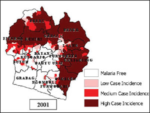
This GIS map, created on ArcView8, has 4 categories of malaria distribution: Malaria free, Low case incidence (1 case for every 1,000 pop.), Medium case incidence (1-5 cases for every 1,000 pop.), and High case incidence (5+ cases for every 1,000 pop.) The map shows how in 2001 the plains region and exposed coastal regions had become increasingly affected by the disease. The GIS investigation allowed researchers to have faster reaction times with data collected from the field, and aided in the transport of resources necessary to control an outbreak.
The article is from ArcNews Fall 2003 Issue, found on: http://www.esri.com/news/arcnews/fall03articles/investigating.html
- Isabella Vargas
It's interesting to hear that the disease is spreading to the flat plains regions as I'm assuming that the mosquito is more confined to the elevated areas of the district. I wonder if the disease is becoming more infectious then just by the bite of a mosquito and has found another way to be transmitted. That could be the reason for the spread, as that could be an interesting experiment to figure out.
ReplyDeleteIt'd be interesting to compare that map of affected humans with a map of the populations of the mosquitos carrying the disease. Also, the clash of "natural" borders and human-imposed borders always intrigues me. Malaria doesn't travel or change according to what administrative district it's in; it has so much more to do with the environment. I think realizing the difference between real boundaries that are tangible and visible and boundaries that are sort of arbitrary and exist only on maps is key to working with GIS. One question: you say that the research allowed for faster reaction times, but what do you mean by this? You could be a little more specific. Great article, interesting issue! GIS has a lot of potential in the biomedical field.
ReplyDelete"the clash of "natural" borders and human-imposed borders" you bring up a good point that has caused a lot of researchers big head aches, the modifiable areal unit problem also similar work is done with research on ecological fallacy.
ReplyDeletehttp://qmrg.org.uk/files/2008/11/38-maup-openshaw.pdf
The basic idea is that changing the borders of the study area can have a large impact on the result of the study. While in this case malaria does not respect the administrative borders defining a study area that follows the natural borders of malaria will give better results. The problem is often we are using dataset that are created by governments, and often governments collect data through administrative borders and often different government collect data differently. So when analyzing results make sure to remember that future work may be needed to address any issues with MAUP and Ecological fallacy.