The particular area analyzed was typical of these farm communities in that time period, as a diverse collection of family farms. Summers County portions of the 1912 Big Bend and Meadow Creek (seen above) was the location of analysis.
Obviously, problems of undercount have affected many aspects of the study, and quite possibly many studies in HGIS. The task of topographic cost allocation analysis (cost of travel based on calculations of elevation, slope and aspect) was especially challenging, and was undertaken in order to model the movement of past peoples.
People were divided by boundaries of rugged land and steep slopes, but the proximity brought small communities together. Common destinations at the time were hamlet centers (offered commercial and social services to the community) and country schools. These country schools fulfilled the mandate for rural public education, and were public property sites that were locally administered and provided community events. An example, Ridge School, can be seen below.
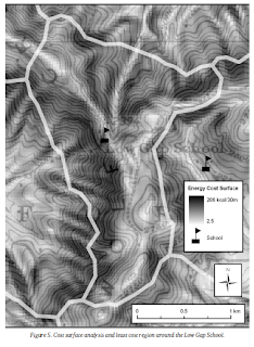
In terms of GIS mapping, NED elevation data was inputted as a raster layer of slope (% vertical rise / % horizontal run). Rivers were assigned a very high value (100,000 calories) to make them into barriers and the resulting zones were compared over various spatial characteristics such as building counts and density. Below is an example of the spatial characteristics around a Low Gap (least cost) School.
Including the hamlets, the map becomes even more comprehensive, as can be seen in Figure 6 below. Both Low Gap School and Ridge School are included.
Some of the results in chart form can be seen below.
Hopefully, studies like this can continue to other regions into the future. The study may be regarded as highly replicable, and the findings may be applied to regions ranging from the social sciences to historical geography.
Towers, George. "Rediscovering Rural Appalachian Communities With Historical GIS." Southeastern Geographer 50.1 (2010): 58-82. Academic Search Complete. Web. 20 Feb. 2012. <http://search.ebscohost.com/login.aspx?direct=true&db=a9h&AN=48811247&login.asp&site=ehost-live&scope=site>


This study reminds me a lot of a new research line dubbed "Spatial Humanities". It is applying these GIS methods to humanities, like historical GIS. To learn more check out this page: http://spatial.scholarslab.org/
ReplyDelete