
Arima, Eugenio Y.,
Walker, Robert T., Sales, Marcio, Souza Jr., Carlos, and Perz, Stephen G.
(2008). “The Fragmentation of Space in the Amazon Basin: Emergent Road Networks”.
699-709.
http://farm3.static.flickr.com/2459/3577304207_39342e49de.jpg
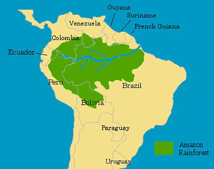
Home to the
world’s largest contiguous tropical forest, the Brazilian Amazon in its
vastness has been losing coverage and its magnificent realm to loggers and those
traveling the roads that traverse the natural forested expanse. Tropical
deforestation has been an ongoing problem, negatively affecting biodiversity
and the carbon cycle. Studying the emergence of deforestation and its patterns,
specifically in relation to the consequences of the road networks that have
branched off to further decimate the Amazon, the authors research the
socio-spatial processes in effect.
Through the
replication of road networks, such as the dendritic
(a common pattern of road fragmentation), GIS is used to map out the area
and provide a greater understanding of the human forces that cause the habitat
fragmentation and its continual proliferation. Decision-making in context with
forested habitat and forested frontiers presents a number of challenges, one of
which is key: resource exploitation and the subsequent degradation of non-human
animal habitat.
Roads built
by loggers present a much greater problem to the environmental integrity of the
Amazon rainforest than do those put in by the federal government. This is
primarily due to the sheer number of them that bifurcate into various others,
no matter the size of the roads themselves. Furthermore, they split off from
the extensive road system already in place, further adding to the destruction,
or often times, the eventual removal of species’ home- both arboreal and
terrestrial. Additionally, the attraction of timber and the ease of access
attracts more people, tracking in more potential for habitat degradation and
loss from the influx of a one-sided, economically-eager human population.
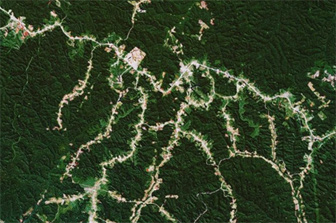
As
mentioned earlier, the forest pattern studied here is classified as dendritic, a pattern that signifies a
specific pattern other than patchy or independent settlement fragmentation,
associated strictly with spatiality. Because of its spatial figure, GIS proves
to be a key factor in the examination of the data, stressing the foremost form
of forest loss due to massive logging practices and transportation of such.
Dijkstra’s algorithm
via GIS tools generates networks and provides the most viable one, the best
possible path after combining each path into a patchwork of data. Linkage of
cells and a direction-to-origin-grid is implemented to eliminate the
unnecessary routes collected. From Dijkstra’s algorithm sprang Tomlin’s heuristic
hydrology approach. With this approach, Tomlin used the flow of water and its
destination to estimate a similar path and thereby pinpoint the path of least
resistance (and hence greater travel) to loggers and the like. Altogether,
raster modeling was utilized to gather a substantial representation of
non-equidistant tress across the Amazonian landscape. In addition,
geostatistics and surveys helped to pinpoint the areas with the highest volume
of timber (which, in turn, were also the areas that required the most roads to
access the timber). The project conducted included forest inventories of over
2,000 Amazonian sites with measurement of trees over 23 centimeters, and the
volume of trees per hectare was also accounted for. This project, based on kriging interpolation aided the researchers
in defining the roads leading to logging sites- categorizing them as determinate
and indeterminate roads. Below is a GIS map to this effect.

(Retrieved
from original article)
Defining the roads from raster
modeling enabled the researchers to calculate the cost of the transverse of
each cell and corresponding route/road. Slopes, rivers, and soil susceptible to
flooding appear to be the most critical cost variables according to careful
observation and surveys taken from loggers in the region. Other factors influencing
cost, of which the majority of this article is focused, constitutes building/infrastructure
costs as well as transportation costs. These costs demonstrate some of the ways
loggers territorialize the landscape before logging is even considered.
Overall the modeling suggests that
loggers make rash judgments and insufficient spatial decisions while lacking
sufficient information about the Amazonian landscape they manipulate. With the
most forest clearance happening within the last decade (referenced in the
article), loggers and all other players for that matter must acknowledge not
only the personal costs they are managing, but also the residual environmental costs.
Loggers’ imprint on the Amazon Rainforest currently is nothing more than an
ominous reminder of the incessant human need for conquering, claiming, and convenience
of nature. Rather than this dreadful impression, loggers and humans globally
should leave behind stepping stones of the natural world, trademarks of the
wonders of the rainforest for successive generations to marvel at in the same
way we do today.
For further reading, check out the article below:
The most typical form of road development, which is awesome to see in Google Earth, is called the "FishBone", where there is a main road that is the spine, with little road jetting out perpendicularly. Check out this pic: https://www.e-education.psu.edu/drupal6/files/geog030/biodiversity/fish_bone_deforest.jpg
ReplyDeleteThis is a very interesting article that shows that lack of planning can have unattended consequences, many of the road networks made are unregulated. One tool that can be used is designating parts of the forest for conservations. Designating a part of the forest as a conservation zone, if chosen in the right place, can cutoff whole sections of forest, making a difference even in parts not designated for conservation. One thing to realize is that the forest is useful for people and supplies lots of services to local people. Many conservation plans take these services away for the local people. The main problem is wood extraction for global market. So cutting off sections of the forest with smart planning of conservation zones can protect even non conserved zones from global forces allowing for local use to continue.
ReplyDeleteThis sort of research is urgent. Once you make an area accessible it seems like it becomes a domino effect of creating lots of little roads which fragment areas of forest, deteriorating the ecological community. If planning for roads avoided this sort of fragmentation, it would really help limit the impact. What people don't realize is fragmenting land creates all sorts of "edge effects", which degrades the habitat both along and within the patches of forest. So just by looking at a picture of the roads, unless you are aware of these side-effects of fragmentation you won't get a true sense of the impact. So maybe another map to help planners could use buffers (output type: dissolve all!) to show the edge effects and how they extend within the fragments.
ReplyDeleteThese roads are displacing a lot of animals and killing them. These animal have never seen a vehicle before so they now have no idea how to cross these roads and are getting killed. Also Like Professor Anwar said these huge companies are taking away resources from the local people who rely on them heavily, but once the resources are gone we will then have bigger problems to worry about. In an article i read a while back it said that the rain forests are only 4% of the Earth's surface but accounts for more than half of the Earth's Oxygen. If these roads do not get planned out carefully (or stop being created) they will eventually mess up the entire rain forest ecosystem and then what will we do for oxygen? GIS please help these people plan accordingly!
ReplyDeleteThis is where the debate on environmentalism often breaks down. It is easy for people in the developed world to say protect the rainforest, but for many living in developing countries, this is a resource that can be used to help grow the economy. The problem is trying to implement sustainable development. President Lula of Brazil stated it nicely in the 2009 UNFCC Meeting in Copenhagen. He said while Brazil is working to responsible develop its resources, he has to balance this with other social demands. He said his campaign promise when running for president was not 'a car in every driveway' like during Hoover vs FDR, it was "3 meals a day for everyone", or to end hunger. It puts some perspective, of course any country wants to develop its natural resources, but the question is how. Unregulated development or sustainable development?
DeleteAnother point about GIS, while it is a great planning tool, it can also be used for resource extraction. Many times maps can have consequence that the author did not expect. For example if a study maps out where all the timber is in the rainforest to help in conservation efforts, this same map can be used in order to find where to extract resources. Remember GIS is a tool, the user is more important in how it is used.
Delete