

They have found that people of every age are attracted to the large size of the maps and can't help but walk around and study them. "So what's going on with all these big maps? Well, we've learned that kids find large maps to be magnetic. And not just young kids. Teens and adults find large maps irresistible as well."

A map this large just begs it viewer to see how far something is from another point. "Most people find they can't just look at these maps. They must walk on them. They count how many steps it takes to get from Beijing to Moscow. They lie down to see if they can reach from the southern tip of India to the northern tip".
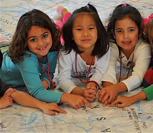
Not only do the map's catch the interest of the viewers but the size allows for more detail to be placed on them. "Unlike regular-sized maps, you can see lots of detail and a large portion of the earth's surface at the same time. Similarly, you don't shift your eyes or turn the page if you want to look at a different location. You move your whole body, like you do in the real world. These maps allow people to interact with a map kinesthetically, experiencing scale and direction as physical sensation".
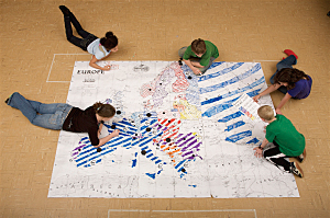
"In fact, some of the most engaging activities for these oversized maps are essentially low-tech versions of geospatial analyses. Have you ever represented a buffer with a hula hoop? Measured a linear distance in units of arm spans?"
http://www.esri.com/news/arcnews/spring11articles/scaling-up-classroom-maps.html
A side note:
I am also attaching the link to the National Geographic page with the information on renting the maps for schools. I though this was cool so I forwarded it to my kids teacher. Something to consider if any of you are a parent with a school age kid yourself.
http://events.nationalgeographic.com/events/special-events/giant-traveling-maps/
This is a good idea, when I was in school the smaller maps that were pulled down really didn't do justice to what it was portraying. I think if kids are taught with these maps it will give them a different perspective on the world.
ReplyDeleteThis is super interesting! I never liked geography as a kid because it was always about memorizing the names of countries and cities and there wasn't any context for it. This makes it all the more exciting and approachable for kids. Definitely something I'm looking into more...
ReplyDeleteIts for these reasons it happens to be improved that anyone can helpful test earlier than building. It will be possible to write more piece of writing like this. gis assignment help
ReplyDelete