

Monday, November 19, 2012

Monday, November 12, 2012
To Swim or Not to Swim?

Though winter will soon be here in
Georgetown, it is never bad to think ahead! In this map I looked at parks relatively
close to Southwestern University and if the parks permitted swimming or not. To
do this I took data from the Georgetown Parks and Recreation website and used
it to determine what the rules regarding swimming are in each park. I then
narrowed down the search just to parks that are both close to Southwestern and
have a viable water source to swim in during the warmer months. The Landrum
Memorial Fountain on campus will always be a mystery as there is no evidence
either condoning or condemning swimming in it.
Wednesday, November 7, 2012
Everything's BIGGER in Texas, Especially Chicken Consumption...

Since being a student at
Southwestern University and becoming a semi-permanent resident of Georgetown, Texas,
I have come to realize that the large majority of fast food restaurants around
the area serve quite a lot of chicken. Before, as a Californian native and
resident, I have never seen so much chicken available to us, human consumers;
yet, of course, this could just be because I have never come to recognize the
abundance of chicken in fast food establishments until now. However, I still
feel like hearty meals of chicken are much more greatly sought after out here
in Texas than my home of California. I mean, seriously, there are five fried
chicken fast food restaurants in the relatively small Georgetown area that sell
almost solely chicken meals to consumers: two Golden Fried Chicken restaurants,
a Bush’s Fried Chicken restaurant, a Wingstop, and a Kentucky Fried Chicken. Let
alone the other 30-something fast food restaurants that also sell some amount chicken
in their menus within this area. Back in my hometown of Garden Grove, we only
had Kentucky Fried Chicken to supply for this obvious human desire for glorious
chicken meat, yet that one main distributor of chicken seemed to be enough for
our town. I believe that southern culture has become accustom to love the
eating all kinds of chicken, in which the city of Georgetown, and many other
southern cities, are attributed with. Therefore, the fast food restaurants of
the area hold true to this cultural characteristic and help provide for the
high demand that comes with this southern obsession for eating chickens. For within
our capitalistic society the following is true: the higher public demand for a
product, the greater availability of that product.
In this observation and belief is
where I was inspired to make this map of the majority of fast food restaurants who
server chicken in the city of Georgetown that I, and many other students of SU,
are bound to find or have found ourselves at frequently to feast. This map has
geocoded the addresses of these restaurants, labeling them throughout this map
of Georgetown with little chicken heads. As you can see from the legend: the
largest heads represent those fast food restaurants that sell almost solely
chicken (Golden Fried Chicken, KFC, etc.), the middle sized chicken head represents
those restaurants whose menus sell a majority of chicken entrées compared to
other options (McDonalds, Jack in the Box, etc.), and the smallest chicken head
show those restaurants that sell a minority of chicken entrées from their menus
(Dairy Queen, Schlotzky’s, etc.). I had received this fast food restaurant
information from the Yellow Pages website, and the menu information came from
the restaurant’s websites. This map gives a good representation of the
magnitude of chicken being sold and consumed constantly in the city of
Georgetown. My hopes for this map are to raise human awareness of this
over-consumption of these plump, flightless birds; and, with that, help people
to realize the variety of negative effects that this intensive demand and
over-consumption has on the chickens, human beings, and the entire world. I
love eating chicken just as much as the next person, however I have always been
one to be wary of glutinous indulgence; as such I try to follow an ethic of moderation
and I wholeheartedly recommend this lifestyle choice to everyone who views my
map.
Monday, October 22, 2012
Speed Limits in Georgetown, Texas

The map above shows the various speed limits throughout Georgetown. If you look closely at the map you will see that the color most visible is a red orange, which is equal to 30 mph. There are over three thousand roads that have a speed limit of 30 mph.
This map was influenced by the maps from a website called http://www.itoworld.com/map/124, that has the entire world mapped and most major streets and what their speed limits are.
Wednesday, October 10, 2012
Most Dangerous Areas for Assault in Georgetown

The Georgetown PD website had a link to a website (http://myneighborhoodupdate.net/) that mapped out the locations for various types of police reports. I looked specifically at the "violent" category and took only the data for assaults. There were a total of 126 assaults. I had to do some manipulation in excel to make it ready for ArcMap, but once I did that, it was easy to geocode the addresses provided for the assaults.
After geocoding, I changed the symbology of the data to show graduated symbols based on the number of police car responders. In ranking the severity of the assaults, I assumed that the number of police cars at the scene correlated to the relative severity of the incident. There definitely appears to be some clustering of assaults, especially with more severe assault incidents.
Georgetown Recreation Trails Map
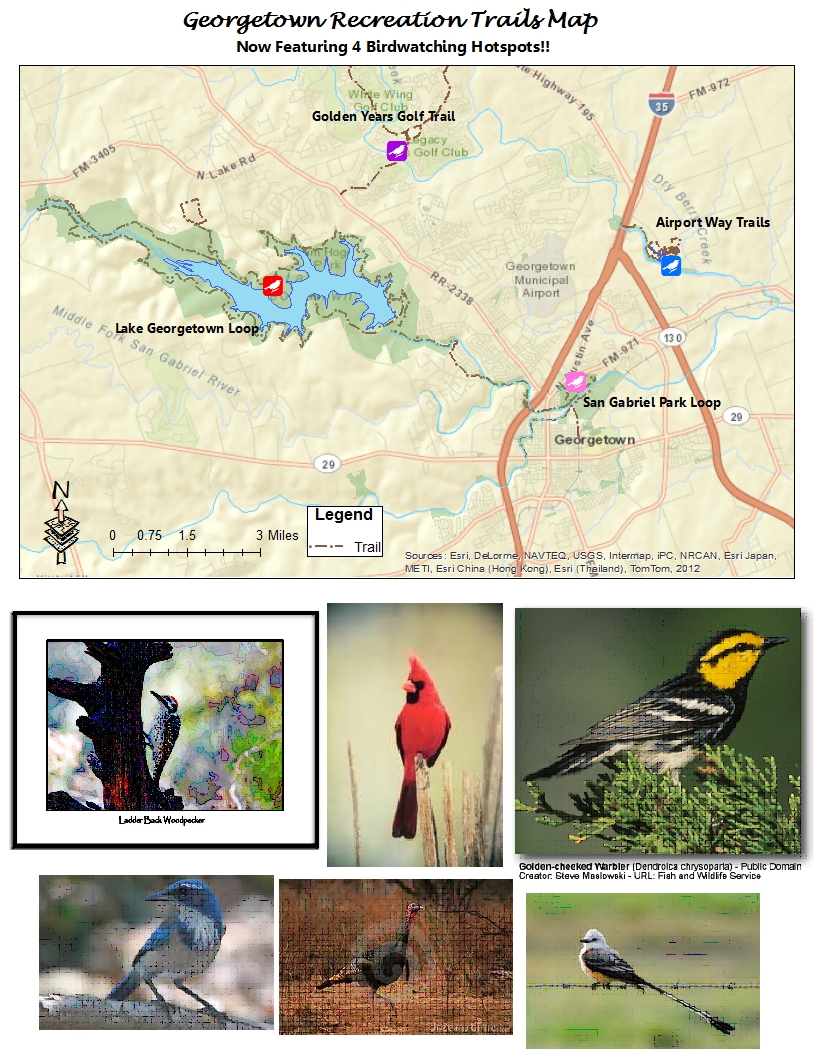
Hotspot #1 – Lake Georgetown Loop (red)
Location: Lake Georgetown- Russell Park, Williamson
County, Texas, US
Date of Effort: May 27, 2012 11:00 AM
Species: 23 total
4 Wild Turkey
1 Neotropic Cormorant
2 Black Vulture
4 Turkey Vulture
2 Mourning Dove
3 Yellow-billed Cuckoo
2 Ladder-backed Woodpecker
1 Eastern Wood Pewee
1 Yellow-bellied Flycatcher
6 Scissor-tailed Flycatcher
3 White-eyed Vireo
4 Carolina Chickadee
8 Black-crested Titmouse
12 Bewick’s Wren
2 Carolina Wren
4 Northern Mockingbird
4 Golden-cheeked Warbler
2 Summer Tanager
6 Northern Cardinal
3 Blue Grosbeak
4 Painted Bunting
6 Red-winged Blackbird
2 Lesser Goldfinch
Hotspot #2 – San Gabriel Park Loop (pink)
Georgetown – San Gabriel Park, Williamson County, TX, US
Date of Effort: August 31, 2012 7:00 AM
Species: 14 (+2 other taxa) total
20 goose sp.
3 Egyptian Goose
10 Mallard duck (domestic)
1 Great Egret
1 Red-Shouldered Hawk
10 White-winged Dove
2 Northern Flicker
2 Eastern Phoebe
2 Blue Jay
3 Carolina Chickadee
1 Northern Mockingbird
5 European Starling
1 Common Yellowthroat
2 Northern Cardinal
1 Baltimore Oriole
2 Lesser Goldfinch
Hotspot #3 – Airport Way Trails (blue)
Georgetown-Berry Springs Park, Williamson County, TX, US
Date of Effort: October 18, 2010
Species: 20 total
Killdeer
White-winged Dove
2 Great Horned Owl
1 Barred Owl
1 Red bellied Woodpecker
1 Ladder-backed Woodpecker
1 Downy Woodpecker
American Crow
Carolina Chickadee
Black-crested Titmouse
1 Golden-crowned Kinglet
Ruby-crowned Kinglet
2 Eastern Bluebird
1 Northern Mockingbird
European Starling
American Pipit
Yellow-rumped Warbler
1 Vesper Sparrow
Great-tailed Grackle
House Sparrow
Hotspot #4 – Golden Years Gold Trail (purple)
Sun-City-Legacy Hills Park, Williamson County, Texas, US
Date of Effort: July, 18 2012
Species: 21 Total
4 Mallard (duck)
2 Green Heron
1 Yellow-crowned Night-Heron
12 Black Vulture
1 Killdeer
1 Mourning Dove
1 Yellow-billed Cuckoo
1 Belted Kingfisher
1 Red-bellied Woodpecker
1 Eastern Phoebe
1 Great Crested Flycatcher
1 Scissor-tailed Flycatcher
2 Blue Jay
1 Carolina Chickadee
1 Bewick’s Wren
1 American Robin
25 Northern Mockingbird
1 Summer Tanager
2 Northern Cardinal
2 Lesser Goldfinch
Vegetation in Georgetown

I wanted to make these maps because I wanted to know what types of vegetation are found in Georgetown, Texas and get a sense of what sort of ecosystem we have built this city in. While driving to the movies, Walmart, or HEB I see large groups of deer and occasionally a raccoon or two walking in the parking lot or road, I wanted to get a feel of where in Georgetown there was still open ground for wild animals such as these. The first map shows where different types of vegetation are found. The second map shows where in Georgetown you can find open space such as parks where development hasn't completely taken over vegetation. Much of the forest and grassland area has been enveloped in development, this map gives a since of nostalgia of what use to and could be. To make this map I got data of where parks and open space is, city blocks are, rivers and streams are, lakes are, and different types of vegetation is, from wilco.org. The map shows that the most open space that is not personal property is found in West Georgetown surrounding Georgetown lake, with a few enclaves around downtown.
Religious Proximity of Georgetown

Data retrieved from:
http://wilco.org/CountyDepartments/GIS/Data/tabid/532/Default.aspx
Lake Georgetown

 Lake Georgetown is a typical
highland type reservoir with steeply sloping banks covered with limestone rock.
Because of water fluctuations aquatic vegetation has a hard time establishing
itself. A moderate amount of standing timber can be found in the backs of coves
and along some shoreline areas, but most cover/structure is in the form of rock
ledges and boulders. In response to the lack of natural vegetation, cedar-tree
fish attractors have been added to provide additional structure. They were
placed by TPWD in cooperation with the Army Corps of Engineers and the Sun City
Hunting and Fishing Club. Most attractors are placed on key structure spots
including drop-offs, humps and roadbeds. Black bass, crappie and sunfish use
the attractors for cover. Fishermen may use GPS in conjunction with a fish
finder to locate these structures.
Lake Georgetown is a typical
highland type reservoir with steeply sloping banks covered with limestone rock.
Because of water fluctuations aquatic vegetation has a hard time establishing
itself. A moderate amount of standing timber can be found in the backs of coves
and along some shoreline areas, but most cover/structure is in the form of rock
ledges and boulders. In response to the lack of natural vegetation, cedar-tree
fish attractors have been added to provide additional structure. They were
placed by TPWD in cooperation with the Army Corps of Engineers and the Sun City
Hunting and Fishing Club. Most attractors are placed on key structure spots
including drop-offs, humps and roadbeds. Black bass, crappie and sunfish use
the attractors for cover. Fishermen may use GPS in conjunction with a fish
finder to locate these structures.
Lake
Georgetown has three boat ramps, all of which are located near the fish
attractors.
Restrooms
|
Parking
|
Courtesy Docs
|
Picnic Area
|
Camping
|
|
Cedar Breaks Park
|
Y
|
Y
|
Y
|
Y
|
Y
|
Jim Hogg Park
|
Y
|
Y
|
Y
|
Y
|
Y
|
Russell Park
|
Y
|
Y
|
Y
|
This Data was collected from the TPWD website, and the Wilson County website
Links for more information:
http://www.tpwd.state.tx.us/fishboat/fish/recreational/lakes/georgetown/
GTography: Georgetown Bike Trails
 | ||||||||||||||||
| Because I made a map in a previous lab depicting the "Top 10 Biker
Friendly Cities" in the U.S., I figured a local portrayal of bike routes
in Georgetown would compliment the national version nicely. The data
was collected from the Williamson County Maps and GIS website (http://www.wilco.org/CountyDepartments/GIS/tabid/454/language/en-US/Default.aspx ), then extracted and exported into ArcMaps. Exported data included the
open/park areas, trails, and roads, and the block census of Williamson
County. I then selected the Georgetown area, then parks and open areas
specifically with the data provided, to hone in on the area of most
importance (that of which encompassed the bike trails in closest
proximity to Georgetown). This map indicates designated trails outlined
in red and named by the corresponding areas they encompass/bisect. With
this map, bikers can take advantage of the trails offered in the city,
while also mapping out their own routes and finding connecting roads to
each of the trails. |
Subscribe to:
Posts (Atom)